Ploemel - Circuit VTT - Au coeur des villages de Ploemel
Crach
3 Rue Henri Le Doré
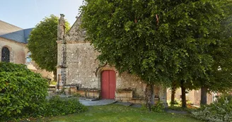
56950 CrachDuration : 2h00Distance : 23 kmDifficulty level : Medium (average height difference: 50m) Course n ° 1 blue This circuit allows you to appreciate the discovery of buildings from different eras, from prehistoric times to 16th century chapels, by paths in the undergrowth and bordering the fields leading from village to village. Departure: This circuit starts in front of the cycle store, Parc d'Activités du Moustoir. A map of the circuit is available in this shop which also offers to rent bikes and make the last small adjustments before departure. After leaving the Parc d'Activites via the North exit, taking rue Henri Doré then rue de l'Europe, continue straight on at the first intersection, then turn left a few meters further on. Continue straight on to a place called Bregoharn, then turn left towards Kerdelam and Toulhouet. Cross Toulhouet following the signs and follow the direction "La Madeleine".Continue on the path to the D119. Take the D119 for a few meters then turn right on the dirt path, still following the markings, which leads to the hamlet of Keraudran. Step by step : 1) Arrived at Keraudran, turn left then immediately right, continue for a few meters on the road before taking the marked path to the left. Follow this path to the village of Locmiquel. 2) In Locmiquel, follow the road which makes a right turn. At the end of the street, turn right then take the dirt path to the left a few meters further. Continue on the path to the Saint-Cado road. Turn left. Take the time to stop at the Chapelle Saint-Cado. Turn left again to enter the hamlet, then take the path on the left that leads to the village of Saint-Laurent. 3) At the end of the path, cross the road to continue on the path opposite to the Saint-Laurent Chapel dating from the 16th century. Leave the chapel behind and turn left at the next intersection to find a path on the right. Follow the path always straight until the village of Poul Hoc'h. 4) Before continuing the path, stop for a few moments to discover the Dolmen of Mané Bogad, a tomb dating from the Neolithic period (between 7000 and 4500 years before the present). To find it, go straight and take the path on the left after the Poul Hoc'h subdivision (be careful, access is reserved for pedestrians). Then retrace your steps, cross Poul Hoc'h to the north before joining the Mané Bogad park trail. Follow the signs to reach the center of Ploemel. 5) In the center, turn right, pass the railway track, keep right and follow the D119 before turning left at Keroulin. Do not miss the Notre-Dame de Recouvrance Chapel and its paintings from the 16th and 17th centuries.Follow the signs to the hamlet of Kerbredeva, turn left. Continue north towards Poulguenan. Head towards the D105 but, at the intersection, take a path to the right which leads, slightly uphill, to the hamlet of Kergal. The route then continues towards the village of Kerbarch. When leaving the village, take a last path on the right to return to the starting point.
Find this route on the Loopi mobile app
Scan the QR code, save it as a favorite, or start the guidance, just enjoy!
Scan the QR code, save it as a favorite, or start the guidance, just enjoy!
Route development
61% shared roads
38% cycle paths
20% cycle routes
14% greenways
Road surfaces
1.71 km on asphalt or tarred road
13.1 km on unknown surface in the Open Street Map database
3.45 km on rolling path (compacted sand, gravel, cobblestones)
4.94 km on trail and off-road track
This route is provided by: Office de tourisme de la Baie de Quiberon
Be cautious and prepared during your outings. Loopi and the author of this sheet cannot be held responsible for any problems that occur on this route.


