Pluneret - Vallon du Léran
Pluneret
1bis Rue Conan Mériadec
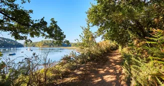
56400 PluneretDuration : 1h15 Distance : 5 km Difficulty level: Easy The hollow paths and the Léran River run through the countryside and the villages of Mériadec. Saint Mériadec was very popular in Brittany and across the Atlantic from the 5th century. Departure: From the village square of Mériadec, cross the D19 and take the rue Yves de Pont Sal (C10) at the corner of the bakery. 1- Continue for 400 m, then turn right to take the hollow path. 2- At the intersection, cross the road, then turn left and continue until the entrance to the Mériadec stadium. Take the path in front of you and follow the path in the undergrowth along the Léran river. The Vallon du Léran shelters several elements of small inheritance: wash house, calvary as well as several sources which testify to the importance of this place in other times. 3- At the exit of the valley, continue on the wide path to reach the heart of the village of Guern Boulard.Turn right and take the road. At the intersection of the D19, cross over the protected passage, turn left, continue for 150 m and turn right at Kerhouarn. This village is home to some pretty Breton cottages and longère. 4- At 250 m, turn right to take the Voie Verte Sainte Anne / Vannes. At the end of the hollow path opposite the entrance to the public school, turn left. (Nearby: an information panel on the “Green Lane”). 5- At the intersection, turn right to return to the center of Mériadec. At the crossroads of rue Parfait Pobéguin (painter from Elven), continue opposite for 50 m then take a right onto the pretty alley (rue du four) which leads to the church square of Mériadec. Mériadec (Bishop of Vannes in the 5th century) was very popular in Brittany where several chapels are dedicated to him. Its reputation was such that the Celts of Wales also worshiped him at that time.The village, crossed by the important Vannes-Quimper Roman road, was already probably a stopover in Roman times. The sustainability of the village was then ensured by the lords of Coët-Sal who created here one of the most important horse fairs in Brittany.
Find this route on the Loopi mobile app
Scan the QR code, save it as a favorite, or start the guidance, just enjoy!
Scan the QR code, save it as a favorite, or start the guidance, just enjoy!
Road surfaces
5.44 km on unknown surface in the Open Street Map database
This route is provided by: Office de tourisme de la Baie de Quiberon
Be cautious and prepared during your outings. Loopi and the author of this sheet cannot be held responsible for any problems that occur on this route.


