Quiberon - Côté Baie : de Saint Julien à la Pointe du Conguel
Quiberon
5 Boulevard de la Teignouse
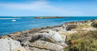
56170 QuiberonDuration : 3h15Distance : 11kmEasy Yellow markup On the first part, this circuit faces the bay of Quiberon, one of the “most beautiful bays in the world”. The Pointe du Conguel gives a view of the entrance to the Gulf of Morbihan and the islands. The end of the circuit allows you to crisscross the city through its small streets. Step by step : Departure: From Port-Haliguen, cross the road and take the coastal path to the south then the boulevard de la Teignouse. At the Pointe du Conguel car park, continue to the orientation table. The tip of Conguel, broken link between continent and islands, junction between bay and ocean, is an extraordinary panorama. See the entrance to the Gulf of Morbihan (orientation table). Offshore, to the south, the Teignouse lighthouse marks an area feared by sailors. The battleship France sank there (1922).1- Take the path that runs along the other side of the point. Continue to boulevard du Conguel.2- Cross it and continue in the undergrowth between the tree climbing and the campsite. At the end of the wood, turn left. Continue the path on the right, pass near the Goulvars Menhir. Erected in the Neolithic period (7,000 to 4,500 years before the present), this bush-hammered stele is 6 meters high. If it appears isolated today, this menhir probably belonged to a larger megalithic complex, as evidenced by the presence of the Conguel Dolmen, located about 150 meters to the south. Turn right on the first path that follows, on the edge of the golf course.3- Rue de l'aerodrome, turn left for 300 m. Follow rue Joseph Le Brix to the right. At the end take the alley along the lake. Take rue Vauban on the right.4- Just after Rue des Douaniers, take the alley on the left, go down the stairs and walk along Place de Port Haliguen. At the end of the square, take the alley leading to Rue de Port Haliguen. Take it to the left for 50 m and turn right onto rue du Mané. Cross rue Surcouf, continue opposite and take rue de Bellevue.5- At the end, turn right onto rue des Galets.Continue left in the Er-Vadjuner impasse. Take Boulevard de Castero to the right as far as the sea. Take the coastal path to the left and continue to Saint-Julien.6- Arriving in Saint-Julien, keep right to reach Rue de la Petite Côte. Take it to the right as far as the coastal path. Follow him to the right. Continue straight on to Port Haliguen.7- Go around the Old Port and take the Boulevard des Emigrés. Walk along Porigo Beach and reach the starting point along Fort Neuf, a former battery built in 1675 at the request of Louis XIV to protect Port-Haliguen from foreign squadrons and pirates. Equipped with a high battery for firing beyond 1,000 meters, it was abandoned at the beginning of the 20th century to be replaced by the buried batteries of Saint-Julien and Port-Haliguen, then largely destroyed.
Find this route on the Loopi mobile app
Scan the QR code, save it as a favorite, or start the guidance, just enjoy!
Scan the QR code, save it as a favorite, or start the guidance, just enjoy!
Road surfaces
11.3 km on unknown surface in the Open Street Map database
This route is provided by: Office de tourisme de la Baie de Quiberon
Be cautious and prepared during your outings. Loopi and the author of this sheet cannot be held responsible for any problems that occur on this route.


