Camors - Circuit de l'eau
Camors
73 Rue de l'Étang
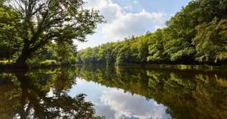
56330 CamorsDuration : 3h Distance : 11 km Difficulty level: Medium yellow markings - All year - Possible MTB Water is omnipresent in the forest of Camors (650 ha): ponds, rivers, fountains. It is home to a variety of wildlife and has, for centuries, fed many woodworkers. Departure: Du Petit Bois, park dedicated to relaxation, recreation and sports with a pond where you can fish, picnic areas, a sports course and a tree climbing park. Walk along the pond and turn left to cross the stream through the small bridge, then follow the sports trail. 1 Turn right towards the Camors forest line and follow the hiking trail (red and white signposting) to the Langroëz locality. Leave the hiking trail on the left and continue on the path then, after 300 m, turn right towards the "Grenan line".At the creek, turn left on a small path, then right to arrive on "the Noë Marrec line". At the end of this line, turn left by a small path, then right by the line of Loges. 2 At the crossroads, turn left and take the D189 for 100 m, then right on the old hollow road. Turn right to enter the forest. See the Sabotiers' fountain. 3 Cross the forest road. Go down the path and turn right to follow the stream of La Motte. Near the pond of the mill of Motte remain the remains of several buildings composing the medieval castle of Comorre, located on a barred spur (rocky promontory whose isthmus was cut by a retrenchment). Follow the stream for 1 km and turn left to find the Petit Bois ponds and the starting point.
Find this route on the Loopi mobile app
Scan the QR code, save it as a favorite, or start the guidance, just enjoy!
Scan the QR code, save it as a favorite, or start the guidance, just enjoy!
Road surfaces
8.89 km on unknown surface in the Open Street Map database
2.41 km on trail and off-road track
This route is provided by: Office de tourisme de la Baie de Quiberon
Be cautious and prepared during your outings. Loopi and the author of this sheet cannot be held responsible for any problems that occur on this route.


