Landévant - Circuit de Lannouan
Landévant
6 Rue De La Grange
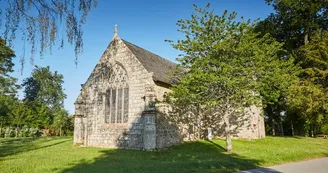
56690 LandévantDuration: 1h Distance: 3.7 km Difficulty level: Easy Yellow markup All year A short hike to discover the Saint-Martin church, the castle of Lannouan, the woods that surround it and the small heritage of Landévant. Departure: From the Church of St. Martin, completely rebuilt in 1834. It replaces a building of the fifteenth century which still some animal sculptures. The inscriptions in gothic characters bear the dates of 1413 and 1422. The tower was built in 1857. Take rue de l'Église, cross the rue Nationale to rue du Bois / rue du Pont Neuf (direction Baud). 1 After the 1st street, turn right on the green alley for 300 m. Cross the street, in front of the tree-lined driveway (private property). 2 Follow to the right, and immediately to the left, the large shady alley.Walk along the perimeter wall bordering the gardens of Lannouan Castle. 3 In front of a wrought iron gate, see the magnificent 18th century castle. Private property, he does not visit. The family of Perrien built the Château de Lannouan after buying, in 1702, the old manor and its outbuildings. Continue the path to the locality of Talvern (very old buildings). At the entrance to the village of Talvern is a wash-house, formerly common to the district and become private following the consolidation. 4 Turn right and return to the village. 5 After 400 m on the road, turn left towards the hamlet of Kerverh. 6 After 100 m on the road, walk right along the fields and then into a small wood (private property). 7 Cross the Talvern stream. Continue following the markup through a subdivision. 8 Take a left and follow the path. Before crossing the street of Auray, look on the right a superb window lintel (9 rue d'Auray) which has two figures:Landévant and his wife, surrounded by tools of masons. It is a lintel reused during the construction of the house. 9 Cross the street of Auray to join the rue de la Grange, opposite. At No. 2 of this street, see a well characteristic of Breton wells (2 rue de la Grange, private property). It is surmounted by five balls marking the number of families who had the right to use it. Pass in front of the presbytery, an Iron Age stele is present in the garden. This funerary stele dates from the Tene (between 450 and 25 BC). Formerly located in the cemetery (Rosenzweig), it may have been Christianized during the first Christianization of the territory. The stele was probably moved at the end of the 19th century when the cemetery (1891) was moved into the garden of the present presbytery.
Find this route on the Loopi mobile app
Scan the QR code, save it as a favorite, or start the guidance, just enjoy!
Scan the QR code, save it as a favorite, or start the guidance, just enjoy!
Road surfaces
3.69 km on unknown surface in the Open Street Map database
This route is provided by: Office de tourisme de la Baie de Quiberon
Be cautious and prepared during your outings. Loopi and the author of this sheet cannot be held responsible for any problems that occur on this route.


