Pluvigner - Circuit de Saint-Guénaël
Pluvigner
39 Rue Saint-Guenahel
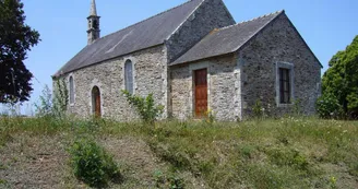
56330 PluvignerDuration : 2h Distance : 8.4 km Difficulty level: Easy Yellow markings - All year round This route through the pluvignoise countryside, from the chapel and the fountain Saint-Guénaël to the wash-house of Ker-Ivo and the woods of the castle of Kéronic. Departure: Take the dirt road in front of Saint Guénaël Chapel. In 1888, a peasant farmer of the Park sold one of his farms to rebuild, elsewhere, the Chapel Saint-Guénaël, in ruins. The original building was near the "Le Pratello" subdivision. Saint-Guénaël removed the cataclysms. This chapel has six bays. The stained glass windows represent Saint Guénaël and Saint Guigner. Walk along the stream and enter the woods: you will find the Saint-Guénaël fountain. Continue the path following the signs and cross the wooden footbridges to the road. 1 At the end of the embankment, turn left on the road. Cross the village of Kercaër.At the exit, turn left on the road and immediately right on the dirt road. 2 Follow the dirt path then enter between the low walls and follow this beautiful hollow road: it leads you to the village of Guiben. Continue on the small road until the RD768. Take a right (attention to traffic). 3 Cross the main road and turn left. Go under the railway bridge, take right immediately on the dirt road, cross the creek: you are in Camors. Go up the path and turn left towards Kerauffret. 4 Cross Kerauffret (respect the calm of the inhabitants) and, at the crossroads, take the road on the left. At a hundred meters, turn right on the path. At the little wooden bridge, you are at Pluvigner. Continue on the path. 5 Climb the superb beech path, pass Mané Gouive. Follow the path that borders the road. Before the intersection, enter the bank on the right, walk along the field and then continue on the road. 6 At the crossroads, turn left towards Kerthomas.Follow this path in the woods of the castle of Kéronic. Go back through the pine forest to the road. 7 At the end of the woods, take immediately to the left the wide path to descend to the village of Malabry. 8 In the village, turn left and go down the dirt road. Continue to the washhouse of Ker-Ivo. Follow the small road on the right and then turn right under the railway bridge on Penn Prat Street. 9 Turn left on Mané Miguel street, at the left again on the RD768, cross and turn right into the residence. Finally turn left and 300 m to find the Saint Guénaël Chapel.
Find this route on the Loopi mobile app
Scan the QR code, save it as a favorite, or start the guidance, just enjoy!
Scan the QR code, save it as a favorite, or start the guidance, just enjoy!
Road surfaces
8.56 km on unknown surface in the Open Street Map database
This route is provided by: Office de tourisme de la Baie de Quiberon
Be cautious and prepared during your outings. Loopi and the author of this sheet cannot be held responsible for any problems that occur on this route.


