Erdeven - Sentier de la vieille route
Erdeven
2 Rue Nationale
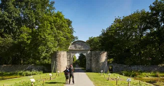
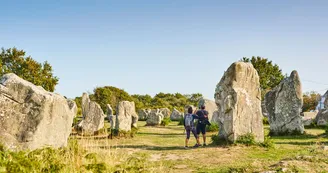
56410 ErdevenDistance: 11.2 km duration: 2.5 hours Difficulty level: Easy All year - Possible MTB Yellow markup In wooded and agricultural area, the old Etel-Vannes route is undoubtedly an old Roman road: rectilinear, located in crest, line of separation of waters. Departure from the place Saint-Märgen, bypass the town hall. Take the rue Nationale on the right. At the crossroads, go to rue du Souvenir. Take opposite the Route de Ploemel then left the rue de Keravéon. 1 At Keravéon, go under the monumental porch then turn left on the sports course. Possibility to see the moat and the facade of the castle. It is to Pierre de Talhouët that we attribute the creation of Keravéon in Erdeven around 1330-1350. Domain erected in seigniory, the Talhouët de Keravéon will remain masters of the place until 1 761. They had for coat of arms a rhombus in banner of silver and sand.This coat of arms appears in several places in the parish church and on the enclosure of the castle courtyard. The commons were converted into lodgings by the municipality of Erdeven who acquired them in the late 1970s. Enter the woods on the right, past the cottages and along the Island of Love. The communal park has a botanical trail with more than 50 tree species listed. At the exit (small door), turn left then right the hollow road. 2 At the road, turn left then at the intersection, take the path on the right. Then turn left into the forest path. The Bois de Coët er Lann is owned by the Departmental Council of Morbihan under the Sensitive Natural Areas. Continue until Keroulard. At the road, turn right. Join Saint-Laurent and its chapel, built in the early 16th century in the flamboyant Gothic style. It is sponsored by the noble family of Talhouët de Keravéon, owner of the neighboring castle in Erdeven.Dedicated to St. Lawrence, invoked in the healing of burns, the chapel has beautiful carved doors, sculptures on the exterior cornices, statues and an ex-voto inside (open every day). Go down the village street. 3 At the bottom of the village, turn right to recover the old road. Take it straight ahead, follow the signs. 4 Before the Corn er Hoët junction turn left towards Kercadio. Seat of a lordship that appears in the sources of the late Middle Ages, the Manor of Kercadio (private) owes its name to the family of Kercadiou (1427). The building is listed in the supplementary inventory of Historical Monuments, in full, since 1998. Cross the D105 (caution), take in front. Follow the signs to join the Kerzerho Alignements which count 195 stones on 200 m and 5 rows. Classified Historical Monument since 1862, it is the western part of the megalithic ensemble Kerzerho-Varquez extending over 3 km. It is, with Carnac, among the largest alignments. 5 Find the starting point by following the signs that lead to it through the town center.
Find this route on the Loopi mobile app
Scan the QR code, save it as a favorite, or start the guidance, just enjoy!
Scan the QR code, save it as a favorite, or start the guidance, just enjoy!
This route is provided by: Office de tourisme de la Baie de Quiberon
Be cautious and prepared during your outings. Loopi and the author of this sheet cannot be held responsible for any problems that occur on this route.


