Erdeven - Sentier de l'Océan
Erdeven > Erdeven
15 Rue Du Grand Large
56410 ErdevenVoie Verte n° 5
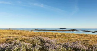
56410 ErdevenDuration: 1h Distance: 4 km Easy All year-Possible MTB Discover the rural roads of Erdeven to arrive at the village and the beach of Kerhillio Departure: From Saint-Märgen square, take rue de la Mairie on the right and then rue Le Barh on the left. Then take a right on rue de l'Océan. 1 At the intersection with the Rue de la Plage, take Lann Vihan Street opposite. Continue straight on rue du Champ Madame. 2 In the bend, continue right on the path. See the Menhir Men Glas which, although it seems isolated, is related to the megalithic ensemble extending from Kerzerho to the Varquez Woods. 3 At the road, take the Chemin des Saules then turn left at 50 m (follow the signs). 4 Continue the small road then the farm road to reach the hamlet of Kermovel. 5 Take the Kergrosse road on the right.In Kergrosse, see the fountain of rectangular plan, covered with large cut granite slabs. It is indicated on the cadastre of 1845. The fountain was restored in 2017 by the Insertion Projects of the Community of Commons, in partnership with the Commune. Its spillway flows towards the Kergrosse pond. In the bend take the Kergrouët trail on the left. 6 Continue to the Boulevard de l'Atlantique, cross it and take the path opposite. 7 Continue to the beach along the tennis courts. Admire the dune range stretching from Gâvres to Quiberon classified Grand Site of France in 2018. Within the Grand Site of France Gâvres-Quiberon, the dune massif of Erdeven conceals an exceptional natural heritage. Its 385 hectares of dunes extend the beach inland. The landscape alternates between a mobile dune, moving according to the winds and tides, a gray where a rough vegetation proliferates, and ponds with remarkable biodiversity and adapted to this particular environment (www.gavres-quiberon.fr).
Find this route on the Loopi mobile app
Scan the QR code, save it as a favorite, or start the guidance, just enjoy!
Scan the QR code, save it as a favorite, or start the guidance, just enjoy!
Road surfaces
1.30 km on asphalt or tarred road
611 m on unknown surface in the Open Street Map database
1.26 km on rolling path (compacted sand, gravel, cobblestones)
1.50 km on trail and off-road track
This route is provided by: Office de tourisme de la Baie de Quiberon
Be cautious and prepared during your outings. Loopi and the author of this sheet cannot be held responsible for any problems that occur on this route.


