Pluneret - Circuit les deux rivières
Pluneret
5 Route De La Chapelle
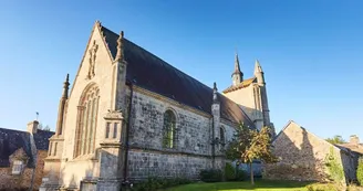
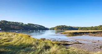
56400 PluneretDuration : 3h Distance : 12 km Difficulty level: Easy Yellow markings -All year The Gulf of Morbihan reveals here all its charms: a great diversity of natural environments where are mixed rural and marine heritage. Overlooking the Sal estuary, the Sainte-Avoye chapel recalls, by its design, this marriage between land and sea. Departure: At the car park of the village of Sainte-Avoye, two shots of situation made by hand by a painter, on an idea of the Town Hall of Pluneret, allow visitors to discover the rich heritage that offers the maritime part of the town . 1 After reading, take the road to the left to get away from the village. At 600 m, in the subdivision of Lann er Villin (the mill meadow), take the path on the left. 2 At the junction of the D101, take a slight right and then cross with caution to the place where the bike path is open and take the path.At the crossroads of the Ballon, turn right on the wide path. At the road, continue opposite to the entrance of the high school Kerplouz-Lassalle. 3 From here, turn right and turn left into the bend. Go under the fast lane then go up immediately on the left by the path leading to the Saint-Goustan cemetery. Turn left to take rue de la Cordonnerie then rue du Rolland to go down to the port of Saint-Goustan. Continue along the Stanguy Promenade. Pass behind the AFPA building and continue along the coastal path. At the tip of Kerisper, see Caesar Buoy in the middle of the river. It marks the location of remains of an aqueduct erected during the Roman antiquity that spanned the river. A little further, see on the left a group of small menhirs visible near the tip of Kerisper, in the ferns. Continue to the old Bono bridge, suspension bridge (1840) listed in the inventory of historical monuments. It is one of the last two examples of this type of construction in France. 5 Continue on the same bank, the path passes near the cemetery of the boats of the Govillo cove. Natural environments characteristic of these vast estuaries, mudflats and salt meadows play with the boundaries between land and water. Bend the cove by the path then, at the crossroads marked by wooden chicanes, continue the coastal path for 1.5 km. Opposite, on the banks of Pluneret and Bono, the quays populated with humble cabins testify to an important oyster farming activity that has disappeared today. The Sal River was one of the cradles of the flat oyster in the Gulf of Morbihan (nineteenth century). 6 At the crossroads, where stands a hundred-year-old oak tree, turn left onto the path that goes up along the meadows. Follows a hollow road that leads to the village of Sainte-Avoye. After strolling around the chapel, go up the road to reach the car park.
Find this route on the Loopi mobile app
Scan the QR code, save it as a favorite, or start the guidance, just enjoy!
Scan the QR code, save it as a favorite, or start the guidance, just enjoy!
Road surfaces
13.2 km on unknown surface in the Open Street Map database
This route is provided by: Office de tourisme de la Baie de Quiberon
Be cautious and prepared during your outings. Loopi and the author of this sheet cannot be held responsible for any problems that occur on this route.


