Quiberon - De la côte sauvage au port de pêche
Quiberon
Rue de Port Kerné
56170 QuiberonDuration : 3h15
Distance : 11 km
Easy
Yellow markings
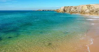
The traces of the fishermen go from Port Maria (1st sardine port in France from 1930 to 1947) to Manémeur, an old fishing village. The wild coastline has impressive cliffs.
Step by step:
Departure: Take the greenway which passes the car park on the left. While remaining careful, cross the road in the bend, at the indicated place, for more safety.
1- Continue on the path of the Côte Sauvage whose cliffs, sometimes more than 20 m high, face the assaults of the west winds and the sea. Continue up to the point of Château Turpault, an Anglo-medieval manor house built by a Cholet spinner in 1910, which marks the entrance to Quiberon (private property). On the way, discover the Covered Alley of the Pointe de la Guérite, a buried tomb dating from the Neolithic period, whose cover slabs are outcropping on the surface. It is located near a menhir.
2- Enter Quiberon by walking along the quays to the fishing port. Walk past the Port Maria ferry terminal (1870) which was the first sardine port in France at the beginning of the 20th century. The fish auction is one of the oldest in Brittany. On the quays,
see the work of art inspired by a poem by Pablo Néruda featuring a fish. Quai de l'Océan, see a concrete parapet, a vestige of the Atlantic Wall. Quiberon was part of the "Lorient pocket", liberated from the German occupation at the end of the Second World War.
Second World War. Continue along the Promenade de la Plage.
3- Go up the Place Hoche and take the street "rue du Phare". Cross the street "rue du Port de Pêche". Go straight ahead by the street "rue du Noroît et des Alizés" up to the street "rue des Hortensias", turn to the left and go up to the street "rue du Manémeur". Turn to the left, then immediately to the right in the street "rue du Couchant" and finally to the left.
4- At the Place du Manémeur, take the track between two houses, and continue on 300 m.
5- Take the path on the right. In the street "Rue des quatre vents", turn to the left. At the roundabout, go straight ahead. Continue on a track towards Kernavest. Cross the street of Kernavest, continue on 150 m. Turn right to the Jardin du Ragot. Go around it on the right and enter it by a small path going down on the left. Leave by the other entrance. Take the track already taken towards Kernevest, and at the fork, turn to the right.
6- At the next crossroads, turn slightly to the left. Go to the tower of Locmaria, vestige of the former semaphore. From the top of the tower, there is an orientation table with a 360° view of the peninsula, Houat, Belle-Île, Groix, Lorient and Quiberon Bay. Continue along the path of the tower and take the next right. At the intersection, turn left at the next crossing towards Kerniscob, then immediately right and finally left, and cross the village.
7- Take the alley of Tiviho on the right on 50 m, turn to the left towards the hill. At the crossroads, go straight ahead, then turn to the right at the next junction.
next junction. Turn to the left on the green way which brings you back to the starting point.
Find this route on the Loopi mobile app
Scan the QR code, save it as a favorite, or start the guidance, just enjoy!
Scan the QR code, save it as a favorite, or start the guidance, just enjoy!
Road surfaces
12.2 km on unknown surface in the Open Street Map database
This route is provided by: Office de tourisme de la Baie de Quiberon
Be cautious and prepared during your outings. Loopi and the author of this sheet cannot be held responsible for any problems that occur on this route.


