Belz - Circuit Etré Douar ha Mor (entre terre et mer)
Belz
45bis Rue Des Sports
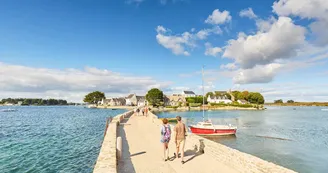
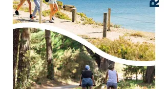
56550 BelzDuration : 3h30 Distance : 12 km Difficulty level: Easy Yellow markup All year long - wet parts in winter Located in the heart of the Ria d'Étel, Belz surprises with its rich natural heritage, architectural and megalithic. This tour gives pride of place to the famous village of Saint-Cado, the Ria d'Étel and the megaliths. Departure: From the parking of the stadium, turn right on the sports street then take the small road on the right bypassing the grounds. 1 Continue left rue du Stade, cross rue de Kerdonnerc'h. Continue in front. 2 Join Crubelz by the trails. Continue on the road then take a left on Er Braden Street. After 100 m, take the path on the left to join the Route d'Auray. 3 Cross it (danger, traffic), go to the Ganquis. Continue for 100 m after the cottages then turn left on Kervilaine.Take the road Ninézur right then take the coastal path left at Pont Carnac. Continue to the tip of Perche Kerhuen. Panoramic view with orientation table. Possibility to observe many birds (coots). 4 Turn right at the end of the beach, rue du Vieux Kerhuen. In the hamlet, stone houses (1,625), sundial, and Dolmens de Kerhuen at the top of the hill to the left. Megalithic site originally consisting of 2 corridor tombs and a megalithic chest, only the two dolmens are visible today. These Neolithic tombs were included in an architecture of earth and stone (tumulus) whose only base is visible today. The dolmens were restored in 1932 by Zacharie Le Rouzic. Like many Neolithic tombs, the monument is located on a high point, thus marking the landscape. 5 At the top of the rue du Lannion, go down to the rue des Moulin des Oies. Below, on the right, see the Moulin des Oies Dolmen, excavated and restored by Z. Le Rouzic in 1931. Before the stop, turn right on rue de la Fontaine.At the bottom, turn right on the coastal path to Saint-Cado. Go around the island, connected to the mainland by a stone bridge that allows you to admire the house of Nichtarguer with its blue shutters built in 1894. In the early twentieth century, this port was the largest sardine port of the Ria of Etel. The island is home to a Romanesque chapel from the 11th-12th century, a calvary dating back to 1832, houses of merchants and fishermen. 6 Walk along the docks to Pen Perleieu Street. Orientation Table Street Pen Mané Arms. Take a right on Pont Er Iaul street. 250 m, at the fountain, turn left on the small path to join the road to Pont Lorois. Take it on the left and turn right just after the bridge. 7 Continue along the hollow path to Dolmen de Kerlutu (Clerment Roh Clour). As they lay on the ground, the pillars of the tomb were straightened and a masonry was added during its restoration in 1935 to keep the pillars and the cover slab in place. After the dolmen, continue on the right until you reach the gymnasium.Join the street Sports and parking. Focus: • The Er Mané dolmen is a gallery dolmen. He presents two burials. The buildings are located on the heights of the village, topographic position identical to all the corridor and chamber tombs. The burials, consisting of vertical supports and megalithic slabs, form more or less circular chambers. • The dry stone is used as wall element of the corridor and the chamber, and is placed in the interstices of the vertical slabs. The supports of the room seem to have been surmounted by a wall to support and stabilize the megalithic cover. The slabs have almost all disappeared in Er Mané. At the back, the Er Bernis dolmen has only kept its vertical walls. • The island of Saint Cado is connected to the mainland by a stone bridge that allows you to admire the house built in 1894.At the beginning of the 20th century, this port was the largest sardine port in Ria d'Etel. It now houses a 12th century chapel and fishermen's houses.
Find this route on the Loopi mobile app
Scan the QR code, save it as a favorite, or start the guidance, just enjoy!
Scan the QR code, save it as a favorite, or start the guidance, just enjoy!
Road surfaces
1.67 km on asphalt or tarred road
5.60 km on unknown surface in the Open Street Map database
974 m on rolling path (compacted sand, gravel, cobblestones)
2.30 km on trail and off-road track
This route is provided by: Office de tourisme de la Baie de Quiberon
Be cautious and prepared during your outings. Loopi and the author of this sheet cannot be held responsible for any problems that occur on this route.


