Saint-Pierre Quiberon - Kerhostin, Portivy, Côte sauvage
Saint-Pierre-Quiberon
1 bis Rue Curie
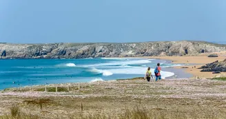
56510 Saint-Pierre-QuiberonDuration : 3 hoursDistance : 10kmAverage Yellow markup This walk presents the two coastal faces of the Quiberon peninsula, the wild coast with its dune massif on the west side, the bay, open to the ocean on the east side. It allows the discovery of some beautiful villages like Kerhostin and the fishing port of Portivy as well as remarkable Neolithic sites. Step by step : Departure: Opposite the Tourist Office, take Chemin Park Praner as far as the D768, cross it. Continue along Chemin de la Fontaine, towards Le Roch, to the Dolmen de Roch en Aud, a megalithic tomb dating from the Neolithic period (5,000 to 2,500 BC), located on the village square.1- Take the chemin du Rouzenn, at the back of the square, towards Kerhostin. Cross the D768 again, take rue de la Baie, then right, rue de la Roche Noire.Continue north along the Sentier des Douaniers which leads to the Bois Maufra (Breton painter born in 1861, died in 1918, who attended the School of Pont-Aven and met Paul Gauguin). Panorama over the whole bay (Port Haliguen, Teignouse lighthouse, Houat, Rhuys peninsula, Carnac, Penthièvre).2- Bypass the small fort, arrive opposite the Fort de Penthièvre (1748-1850, possible visit to the memorial and the crypt in memory of the 59 patriots killed during the Second World War). Cross the road and the Fort level crossing (be careful,passage of trains in summer and bicycles on the cycle path). Gain the seaside. Beautiful view of Lorient, the island of Groix and the Téviec island (or Guernic islet) located offshore (not on the map), famous for its Mesolithic necropolis discovered by Marthe and Saint - Just Péquart at the beginning of the 20th century (uncovering of a set of dwellings and ten burials containing a total of 23 adults and children dating from the 6th millennium BC). Follow the coast to the south.3- Continue towards Portivy via the Téviec promenade.Pass near Thinic Island (Bronze Age necropolis - 2200 to 800 BC). Continue the coastal path towards Fozo beach and Beg en Aud. Admire the Tumulus de Beg en Aud (neolithic tomb). Pass the tip of Percho. Discover the ruins of an old artillery observatory.4- Pass near the Dolmens of Port Blanc, two passage tombs from the Neolithic era which yielded around fifty skeletons. Reach the arch of Port Blanc and continue towards Port Rhu.5- At the car park, turn left into Rue de Port Rhu. Continue along rue de Kergroix. At the end, cross the Departmental to reach the station. Cross the level crossing and turn right into rue Clémenceau. At the end, cross the road and take rue Curie at the corner of the Cultural Center to find the Tourist Office.
Find this route on the Loopi mobile app
Scan the QR code, save it as a favorite, or start the guidance, just enjoy!
Scan the QR code, save it as a favorite, or start the guidance, just enjoy!
Road surfaces
2.54 km on asphalt or tarred road
3.63 km on unknown surface in the Open Street Map database
296 m on rolling path (compacted sand, gravel, cobblestones)
4.29 km on trail and off-road track
This route is provided by: Office de tourisme de la Baie de Quiberon
Be cautious and prepared during your outings. Loopi and the author of this sheet cannot be held responsible for any problems that occur on this route.


