Hoedic - Tour de l'île
Hœdic
85 Le Bourg
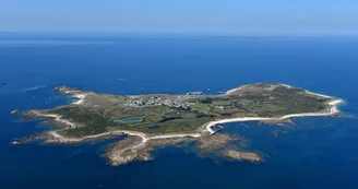
56170 HœdicDuration: 2 hoursDistance: 8kmEasyFollow the coastal path. Departure: From Port D'Argol, follow the coastal path to the right behind the ferry terminal. Step by step : 1- See on the left the Douet pit (former washhouse) and, on the right, the Gadouen cove, Port l'Eglise and the old lifeboat house.2- After the granite coast, not far from Port Neuf, a causeway built by German prisoners collapses on the shore. The archaeologists Saint-Just and Marthe Péquart discovered Mesolithic tombs which constitute, with Téviec, the most important Mesolithic necropolises in Europe (one of the skeletons is in the Museum of Prehistory, Carnac). The mica schists make the cove of Men Du to the north sparkle.3- Pointe du Vieux Château is a barred spur (fortified habitat) marking the landscape and dating from the Iron Age. An alignment of menhirs is also visible on this point.In the time of the sailing navy, the fleets took shelter in the harbor in the north of the island, “Chambre d'Hoedic”, before attacking Belle-Île or the mainland.4- The tip of Caspéraquiz, facing the Calvary of Port Blanc, has piles of stones. 5- The first village of Hoedic was located in Paluden. An alignment of menhirs is visible to the south of the hamlet. 6- The Lost House was the shelter of the quarry workers during the construction of the Fort. You can access the Tourelle de Beg Melen at low tide.7- The Fort (1853) was decommissioned shortly after its construction. It hosts a stopover gîte, associations, an exhibition on the island's heritage. 8- Gulls nest at Grand Mulon.9- The Menhir of the Virgin and the Dolmen of the Cross, classified Historic Monuments, have become places of processions (18th century). A statue of the Virgin at the top of the Menhir, which has disappeared today, and the cross on the cover slab of the dolmen buried under its tumulus show the Christianization of these megaliths.A lying menhir is also visible to the northeast of the site.10- Treh Signago served as a shelter for the Sinagots and the fishing boats of the Gulf of Morbihan.11- Pointe Beg Lagad hosts a Fort Vauban.12- The old houses of the village are low farmhouses. The church, rebuilt in 1853, dominates the island and the sea, a little away from the village. The old semaphore (1861) shelters a lodging.
Find this route on the Loopi mobile app
Scan the QR code, save it as a favorite, or start the guidance, just enjoy!
Scan the QR code, save it as a favorite, or start the guidance, just enjoy!
Road surfaces
7.68 km on unknown surface in the Open Street Map database
This route is provided by: Office de tourisme de la Baie de Quiberon
Be cautious and prepared during your outings. Loopi and the author of this sheet cannot be held responsible for any problems that occur on this route.


