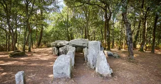
Erdeven - Sentier des Mégalithes
Erdeven
13 Rue du Stade
56410 ErdevenDuration : 2.5 hours Distance : 10,6 km Easy All year - Possible MTB Discovery of the multiple megalithic sites of Erdeven: alignments of menhirs, dolmens, megalithic enclosures ... Step by step : Departure: From the Saint-Märgen square, bypass the town hall and take the rue Nationale on the right. At the crossroads, go to rue du Souvenir and rue Tenat er Velin on the right. 100 m, cross it. Follow the path to Dolmen de Botlann.- At 100 m, cross it. Follow the path to the Botlann dolmen. 1 Continue right along the path to reach the Rue du Calvaire. Take Lann Huen Street on the left. After 250 m, take the path on the right. 2 After one kilometer, turn left and then right towards the Dolmens de Mané Braz ("the big hill" in Breton).The site includes 4 different corridor tombs (single chamber, lateral cell chamber and compartmentalized chamber) and certainly erected at different periods of the Neolithic, the most recent being the compartmentalized chamber (-3 500 BC). They were restored by Zacharie Le Rouzic in 1923. At the next intersection, turn left then continue the path. To the left are the Mané Braz Alignments (partly private) that are part of the megalithic ensemble from Kerzerho to the Varquez Woods. Continue the path to Coët Er Blei Alignments ("Le Bois du Loup"), known as "La Chaise de César". Go to the parking Varquez. Go up to the left to the Dolmen of Mané Croh, falls to corridor with compartmentalized room. It was formerly included in a tumulus today almost completely disappeared and was restored by Z. Le Rouzic. 3 From the car park, take the path on the right and take the road to Crucuno. See the Crucuno Dolmen, a monument stripped of its tumulus and access corridor, formerly described by W.Lukis (1864) as measuring a total length of 27 meters and still visible on early nineteenth century engravings. Today, only the funeral chamber remains under an imposing slab of cover of more than 30 tons. On the square, bypass the dolmen and continue towards the Quadrilateral of Crucuno, megalithic enclosure composed today of 22 menhirs, including two lying, measuring 34 m by 26 m. Historical Monument since 1889, it was restored by Felix Gaillard at the same time. The latter erected and placed the menhirs, then lying down, in order to orient them on the cardinal points and to make the diagonals correspond to the sunrises and sunsets at the solstices. To go back. 4 Take the road opposite towards the housing developments towards Triono. Take the path on the right towards the village of Kerbernes. Cross it to take the path in front. 5 At the next crossroads, take the left-most path and then immediately again on the left.Continue the mining path to the Kerzerho Alignments, which is the western part of the Kerzerho-Varquez Megalithic Complex and has 195 stones in 200 m and 5 rows. Restored in 1884 by Felix Gaillard, some blocks were straightened. The largest menhirs, called "Giants of Kerzerho", measure about 6 meters tall for 40 tons. 6 Return to the village by the street of Calvaire, on the right the path of Botlann, on the left the street Tenat Er Velin, on the right the street of the Souvenir and on the left the street National. Focus: • The dolmens of Mané Braz ("the big hill" in Breton) gather 4 dolmens in different states of conservation. • Caesar's chair is a set of isolated menhirs located in Coët er Blei (the Bois du Loup). • The Mané Croc'h dolmen is 6 m tall. • The Crucuno quadrilateral has 22 menhirs. • The Kerzerho Giants are about 6 m tall for 40 tons. • The Kerzerho menhir alignments consist of 195 stones over 200 m and 5 rows. Historical Monument since 1862, it is the most important Breton megalithic site after Carnac.
Find this route on the Loopi mobile app
Scan the QR code, save it as a favorite, or start the guidance, just enjoy!
Scan the QR code, save it as a favorite, or start the guidance, just enjoy!
Road surfaces
2.00 km on asphalt or tarred road
2.15 km on unknown surface in the Open Street Map database
1.20 km on rolling path (compacted sand, gravel, cobblestones)
6.42 km on trail and off-road track
This route is provided by: Office de tourisme de la Baie de Quiberon
Be cautious and prepared during your outings. Loopi and the author of this sheet cannot be held responsible for any problems that occur on this route.


