Crac'h - Circuit cyclo - Circuit des trois ponts
Crach
Place René Le Mené
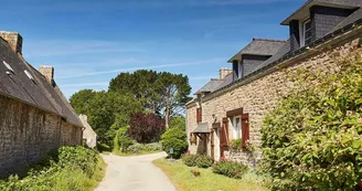
56950 CrachDuration: 1h10 Distance: 14 km Difficulty level: Easy All year Very nice walk to discover the birth of the Crac'h River. Departure: Place Le Mené, facing the Town Hall, take direction Le Tourbillon. 1 Take the path north towards Kerbiscam, along the villages of Petit Cosquer and Kéricart. Cross the VC203 direction Le Lerré, then join the VC6. To discover on the way, a little behind, the pretty cross of Kerbiscam. Of great height, the cross is removed in the moor not far from the road. It is located on the old road that connected Kericard to Kerbiscam. 2 Turn left on the VC6 for 400 m to the crossroads of Menhir. Take direction Le Lerréo, then the Grand Cosquer. 3 At the exit of the village, do not miss the detour Béquerel, "where comes to die the tide and where the stream joins the sea".Attention, located on a private property, the place can not be visited. Return on the VC 240 direction Le Vigueah. At the bottom of the village a very nice work, the Bridge of the three cantons. Under this bridge flows the stream that flows into the salt water where begins the river Crac'h. 4 Go back to the village of Vigueah to take the path towards Kerberen through Kerbourda and Bréharve. 5 At Kerberen, go down the VC1 for 300 m and take the path towards Kervive. On the outskirts of Kervive, on this wide old path, discover another beautiful bridge, the "Roman Bridge" or "Pont Pesket" where flows the stream that flows to Vigueah. 6 At the bottom of the village of Kervive, make the detour to the Menhir of Kervive, built in the Neolithic (7000 years to 4500 years before the present). Take the direction of Kersinge, Le Lerré then Kerbiscam through the Crac'hoise countryside. 7 Iron in front of the Cross of Kerbiscam. Then cross the VC203 then join the town center along the villages of Kéricart and Petit Cosquer.
Find this route on the Loopi mobile app
Scan the QR code, save it as a favorite, or start the guidance, just enjoy!
Scan the QR code, save it as a favorite, or start the guidance, just enjoy!
Route development
94% shared roads
5% cycle paths
Road surfaces
325 m on asphalt or tarred road
9.52 km on unknown surface in the Open Street Map database
7.43 km on rolling path (compacted sand, gravel, cobblestones)
1.10 km on trail and off-road track
This route is provided by: Office de tourisme de la Baie de Quiberon
Be cautious and prepared during your outings. Loopi and the author of this sheet cannot be held responsible for any problems that occur on this route.


