La Trinité-sur-Mer - Sentier des douaniers
La Trinité-sur-Mer
3 Môle Loïc CARADEC
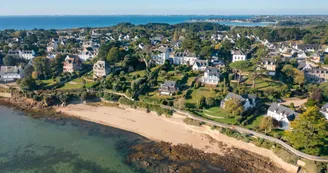
56470 La Trinité-sur-MerDuration : 1h30 Distance : 6 km Difficulty level: Easy GR and yellow markings - All year round The trail leads from beach to beach, to the Pointe de Kerbihan and its view of the Bay of Quiberon. it allows the discovery of salt marshes rehabilitated Kervillen. Departure: From the course of the quays, follow the port to the south. The south pier (Éric Tabarly mole) and the first pontoons and the grounding slip were built in 1963. The Société Nautique de la Trinité is located on this part of the port. The fishing port has existed since the dawn of time. It is closed by the mole of the fishermen which was widened and prolonged in the fifties. The Central Dock and the Caradec Mole date from 1975, the North Dock is the most recent and was built in 1994. At the end of the harbor, take the coastal path that starts at the anchor. Walk along Men Allen's beach with a convex shape.Continue towards the Bois d'Amour, along the large houses of the early twentieth century. At the beach of Kerbihan, reach the beach of Grazu, then the tip. 1 At the tip of Kerbihan is "Ty Guard", a former customs house guarding the bay (private property). After the peak, follow the path to the large beach of Kervillen. Get on the car park and cross it. Then continue along the salt marshes, restored in 2012 under the auspices of the Department of Morbihan and the municipality, as part of the preservation of sensitive natural environments. These salt marshes, the most northerly in Europe, cover about one hectare. The salt worker who exploits them produces about ten tons of salt a year. 2 Turn right towards the salt loft then, at the next crossroads on the left, and again on the right to the Poulbert pines (picnic tables). Cross the wood and join the Departmental. 3 Turn right onto the track along the road. At the intersection with Kervouden street, turn right. Variant :possibility to turn left to make the round trip by the path of the Vigie along the Quéric-Kerdual Marsh. After 50 m, turn right on rue de Kervouden, take rue du Gréal on your left. Continue to the crossroads. 4 Continue left into Kerhino Street. At 50 m, turn right on Chemin de la Hune and continue straight on to find the coastal path. Take it on the left to reach the port.
Find this route on the Loopi mobile app
Scan the QR code, save it as a favorite, or start the guidance, just enjoy!
Scan the QR code, save it as a favorite, or start the guidance, just enjoy!
Road surfaces
7.15 km on unknown surface in the Open Street Map database
This route is provided by: Office de tourisme de la Baie de Quiberon
Be cautious and prepared during your outings. Loopi and the author of this sheet cannot be held responsible for any problems that occur on this route.


