Carnac - Circuit de Saint-Colomban
Carnac
16 Place de l'Église
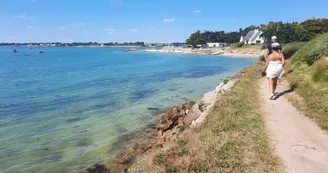
56340 CarnacDuration : 2.5 hours Distance : 10 km Difficulty level: Medium Yellow markup Take the path that the inhabitants of the village of Saint-Colomban were still following at the beginning of the last century to go to the village. Departure: The departure is Place Saint-Cornély, in front of the Tourist Office. 1 Leave on your left the Saint-Cornely church (17th century, one of the most beautiful religious monuments of the Renaissance style of Morbihan), towards La Poste, then at La Fontaine, turn right to reach the supermarket. After 30 minutes of walking, admire the view of the Anse du Po, former port of Carnac and seat of intense activity (trade and shipbuilding), today cradle of oyster farming. 2 Join the village of Saint-Colomban dominated by its Flamboyant Gothic Chapel, dedicated to Saint-Colomban, Irish missionary monk (late 16th century). To the left of the altar, restored wall paintings represent two galleons in the colors of the English fleet.Its inhabitants have lived for a long time on land and sea. 3 Follow the walkway towards the beach of Saint-Colomban with very fine sand and very white. See by the sea 2 chimneys, vestiges of a forge. At the Pointe, the view of the bay and the peninsula of Quiberon is exceptional. 4 Take the walkway back to the nautical base. The reputation of the Yacht Club is well established due to the variety of water activities on offer and the importance of its events. 5 Cross the small bridge to Port En Dro, former fishing port of Carnac, and leave the thalassotherapy center on the right. 6 Return to the starting point via the Emigrants' Cross. It commemorates the mass said here during the landing of the royalist emigres (1795) on the beaches of Légenèse and Saint-Colomban as well as on the village of Bréno.
Find this route on the Loopi mobile app
Scan the QR code, save it as a favorite, or start the guidance, just enjoy!
Scan the QR code, save it as a favorite, or start the guidance, just enjoy!
Road surfaces
2.26 km on asphalt or tarred road
3.57 km on unknown surface in the Open Street Map database
2.56 km on rolling path (compacted sand, gravel, cobblestones)
1.22 km on trail and off-road track
This route is provided by: Office de tourisme de la Baie de Quiberon
Be cautious and prepared during your outings. Loopi and the author of this sheet cannot be held responsible for any problems that occur on this route.


