Houat - Tour de l'Île
Île-d'Houat
291 Port de Saint Gildas
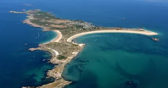
56170 Île-d'HouatDuration: 3h30 Distance: 14.3km Easy Follow the coastal path - Poles with iron ends prohibited The high granite cliffs of Houat extend the Quiberon peninsula to which it was attached. The village is grouped directly above the fishing port, an important activity. The coast is of rare beauty, the flora is rich and diversified. Departure: From the landing stage, take the coastal path on the right. Step by step : 1- Sheltered from the prevailing winds, the north coast seems a little less harsh than that of the southwest. From Beg Carpaliée to Beg-er-Vachif, the high, dry moor descends to the sea. Near the village, there are fallow meadows and gardens with European gorse, bell heather, blackthorn, eagle fern, nesting passerines , herring gulls, green lizards and common walls.2- At Beg-er-Vachif, view of the Guric and Séniz islets, connected to the island by a small sandy tombolo which appears at low tide: herring, brown and sea gulls, one of the main colonies of crested cormorants and oystercatchers. 3- The south coast, wild and unspoiled, between cliffs and creeks, is unique in Morbihan. To see: cove of Treac'h-er-Venigued, Beg-er-Vachif (view of the Chaussée du Béniguet, the mainland), "er Beg" promontory (view of Belle-Île, Hoedic, Île aux Chevaux, Treac’her-Goured). Remarkable species: sand quillwort, Portuguese ophioglosse, common raven, northern wheatear, Belon's shelduck.4- In the center, a plateau, formerly cultivated, is leveled by marine abrasion and in the process of colonization by the moor. Seen from the fort, it constitutes a preserved landscape entity: high moor with European gorse, patches of dune grass, fallow meadows. Several megalithic monuments erected in the Neolithic period (7,000 years to 4,500 years before present) are also visible in this space.5- The dunes and beaches of Treac'h-er-Goured and Treac'h-Salus form one of the most beautiful dunes in Brittany: there are many remarkable species, including the abundant sea lily. The skylark and the northern wheatear nest there.6- The large rock mass of Er-Yoc'h islet is home to a large colony of English shearwaters, very rare in France.
Find this route on the Loopi mobile app
Scan the QR code, save it as a favorite, or start the guidance, just enjoy!
Scan the QR code, save it as a favorite, or start the guidance, just enjoy!
Road surfaces
14.4 km on unknown surface in the Open Street Map database
This route is provided by: Office de tourisme de la Baie de Quiberon
Be cautious and prepared during your outings. Loopi and the author of this sheet cannot be held responsible for any problems that occur on this route.


