Erdeven - Circuit VTT - Entre mer et forêt
Erdeven
15 Rue Du Grand Large
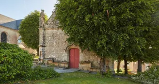
56410 ErdevenDuration : 2h30Distance : 38 kmDifficulty level : Medium (average height difference: 200m) Course n ° 4 red From the Atlantic coast to the Erdeven forest, from the dune cordon to the megalithic complex of Varquez, or from the Sac'h mill to the Saint-Laurent chapel, this circuit has been designed to appreciate the variety of landscapes and the riches heritage of Erdeven, Etel, Locoal-Mendon, Belz, Plouharnel and Ploemel. Departure: This circuit starts from the parking lot of the Grand Large sports complex, located rue du Grand Large in Erdeven. Step by step : 1) Follow the signs, the first kilometers lead to the coast at the level of the Roche Sèche site. The route then follows the dune cordon until the Barre d'Etel.2) Take the direction of Etel and reach the Sac'h mill, built in the 17th century.Only the dyke and its old valves are evidence of hydraulic operation, while the buildings have been altered by alterations in the 1950s and recently. 3) Take the wooded areas of Belz and Locoal-Mendon then walk along the golf course of Ploemel and the Chapelle Saint-Laurent. Built at the beginning of the 16th century in the Flamboyant Gothic style, this chapel was commissioned by the noble family of Talhouët de Keravéon, owner of the neighboring castle in Erdeven. It is dedicated to Saint Laurent, a young deacon, martyred on the grill on August 10, 258, who is invoked in the healing of burns. The chapel has beautiful ornate doors, sculptures on the exterior cornices, statues and an ex-voto inside. 4) Take the time to visit the Dolmensde Mané Braz ("the big hill" in Breton), site grouping together 4 tombs with different passageways (single room, room with side cell and compartmentalized room) and certainly erected at different periods of the Neolithic, the most recent being that with compartmentalized room ( -3500 BC), the Dolmen of Mané Croh, or to observe the Alignments of Coët er Blei (or “Chair of Caesar”). Please note, these megalithic sites are only accessible to pedestrians. 5) Reach the village of Crucuno with its Dolmen, stripped of its tumulus and its access corridor formerly described by W. Lukis (1864) as measuring 27 m in length and still visible on engravings from the beginning of the 19th century. Today, only the burial chamber remains under an imposing cover slab weighing more than 30 tons. See also the Quadrilateral of Crucuno, a megalithic enclosure composed today of 22 menhirs, including two lying, measuring 34 m on 26 m. Set off again in the direction of Plouharnel and pass in front of the Saint-Antoine Chapel (18th century).The side statues are those of Saint Anthony and Saint Eloi, invoked to protect cattle and horses. 6) The return is via the V5 and the paths of Erdeven.
Find this route on the Loopi mobile app
Scan the QR code, save it as a favorite, or start the guidance, just enjoy!
Scan the QR code, save it as a favorite, or start the guidance, just enjoy!
Route development
42% shared roads
57% cycle paths
19% cycle routes
13% greenways
Road surfaces
3.70 km on asphalt or tarred road
18.0 km on unknown surface in the Open Street Map database
2.44 km on rolling path (compacted sand, gravel, cobblestones)
14.0 km on trail and off-road track
This route is provided by: Office de tourisme de la Baie de Quiberon
Be cautious and prepared during your outings. Loopi and the author of this sheet cannot be held responsible for any problems that occur on this route.


