Sainte-Anne d'Auray - Circuit cyclo - A deux pas de chez nous
Sainte-Anne-d'Auray
Place Nicolazic
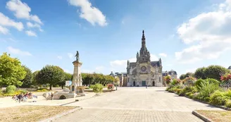
56400 Sainte-Anne-d'AurayDuration : 2h15 Distance : 11,4km Difficulty level: Easy - All year long A walk in the footsteps of the peasant Yvon Nicolazic. Twice, Saint Anne appeared to him. In 1625, he unearths a statue with his effigy. The impact of this story and the influx of pilgrims will make the sanctuary what it is today. Departure : Mairie, direction East going towards Vannes / Mériadec. 1 After 100 m turn right, then left the Boterff trail. 100 m after, turn left. Walk along the area of the White Horse and the north of the village Pen prat. 2 At the intersection, two possibilities. Privilege the right (less road). The hollow paths are the backbone of the grove. They guide with majesty among the closed fields of embankments. 3 Rue du Guern, turn right to the roundabout of the Cross Nicolazic. Take the path of Malachappe on the left which leads to De Gaulle street. Cross it to join the path of Malachappe / Lomelec. 4 At 400 m, turn left towards Lomelec (Pluneret). In Lomelec, take a path of exploitation on the right. Auray appears on the horizon, separated by the Loch Valley. Here, we like to imagine the troops of Charles de Blois and Duguesclin engaging in swamps to attack the castle of Auray (1364). 5 At Gumenen, turn left onto a communal road, reach Kerroussin, leave it on the left and turn right towards Kerloury. 500 m, take the path on the left between hedge and farmhouse. Go down to the reed beds. Observe the nature and the Toul Er Goug Bridge. Retrace his steps to the village. Go up 10 m on your right and turn left towards Kerniolen. At the end, turn left and then the first right. Variation: turn right at the Gumenen pylon, cross the wooded area. At the crossroads, turn left. At the equestrian center turn right to rue Calloc'h. Take it on the left then at the intersection, on the right (if flooded road, take the variant of point 6). 6 Continue straight ahead, past an equestrian center to rue Calloc'h. Take it on the left then at the intersection, on the right. If impracticable road, cross Kerniolen while staying on the road, continue straight. After 350 m, turn right on Porho path (or Pilgrims). At the end of the path, turn right on rue Calloc'h. 7 At 50 m take a small alley on the left. Cross the Parc Cogan allotment, take each time on the right. At the end, turn left to join Parc street. 8 At the roundabout turn left towards Camborne Park. Cross it (toilets nearby). At the car park, take rue de Gaulle. Head left towards the Sanctuary. 9 Cross the sanctuary site. Opposite the Memorial turn left, then right towards the statue of St. Anne. Continue straight on the path along a hedge. At the end, cross the hedge, join the trail along the Necropolis. At the intersection, take the road to Pont Er Groah on the right, then at the end, the Rue de Locmaria to the right to find the Mairie.
Find this route on the Loopi mobile app
Scan the QR code, save it as a favorite, or start the guidance, just enjoy!
Scan the QR code, save it as a favorite, or start the guidance, just enjoy!
Route development
89% shared roads
10% cycle paths
Road surfaces
1.73 km on asphalt or tarred road
8.67 km on unknown surface in the Open Street Map database
384 m on trail and off-road track
This route is provided by: Office de tourisme de la Baie de Quiberon
Be cautious and prepared during your outings. Loopi and the author of this sheet cannot be held responsible for any problems that occur on this route.


