Brec'h - Circuit cyclo - Circuit des chapelles
Brech
9 Rue Georges Cadoudal
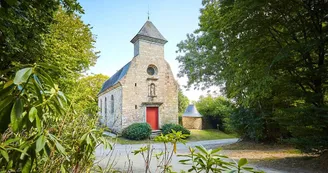
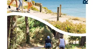
56400 BrechDuration : 2.5 hours Distance : 25 km Difficulty level: Easy - All year long This tour allows to discover the rich historical and religious heritage of the town. Before departure: in front of the town hall, go through the Chapel of Our Lady of Flowers, formerly center of a pardon very busy in Spring. Take the rue du Couëdic. After 800 m take the path on the left towards Kerguiban. Continue until the D768. Turn left 100 m (danger, traffic) then right to Calan. 1 In Calan, admire the Saint-Goal Chapel, which served an important agricultural village. Take right after the calvary then left the path that goes down. Go under the railway, leave immediately on the left, follow the main road to the D19. Possibility to turn right on the D19 to Landaul to reach the Chapel of Tréavrec about 500 m (danger, traffic). The Chapel Notre-Dame de Grace, Renaissance style, dates from the sixteenth century. Then return on the D19. 2 On the D19, after the crossing, turn right towards Kermelen and immediately left on the road. At the end, turn left towards Chapelle Saint-Clément, rebuilt in 1874. Retrace your steps, take the road on the left to Kerhourain. Leave the village on the right, continue straight on. At the stop, turn left then right then left again to reach the rue du Manoir. Possibility of returning to the village, on the left, via Corn Er Hoët. 3 Take rue du Manoir for 1.5 km, turn right towards Kernanec. In the hamlet, take the path on the left. Possibility to take the road on the right which passes under the railway to join the Chapel Notre-Dame of the Road, modern edifice built in 1963 by the agency Guillou, one of the biggest architectural agencies of Brittany of the time. Turn around. Take the opposite road to reach Kerstran Street. Continue to Pipark Road. After school, take the path to the right. At the end, take the alley on the left.Pass by La Chartreuse, former monastery of Carthusian monks (guided tours all year round). Take the road again and then, at the roundabout, go opposite, towards the Champ des Martyrs where about 250 Chouans, royalists, were shot by the Republican troops in 1795. Take the road to join the Chapel of the Champs des martyrs. 4 After the visit, turn right towards Saint-Dégan. At the crossroads, turn left and immediately left, impasse Pont Romain. Continue to Saint-Dégan. At the halfway point, take the road on the left to go back to the Chapelle Saint-Quirin (17th century). Classical style, it houses one of the most beautiful altarpieces of Morbihan. In Saint-Dégan, take the path of the garden of the old meadow and continue in the village on the left to join a hollow road. The Ecomuseum of Saint-Dégan allows you to discover the everyday life in the Pays d'Auray (17th century thatched cottage, 19th century farmhouse and its outbuildings). 150 m to the right, take a path to the road.Take a left and then reach the village by the rue du Moulin de Talhouët. Pass in front of the Saint-Jacques Chapel, whose western facade adorned with sculptures bears the date 1464, then in front of the Saint-André Church (retains elements of the 12th century).
Find this route on the Loopi mobile app
Scan the QR code, save it as a favorite, or start the guidance, just enjoy!
Scan the QR code, save it as a favorite, or start the guidance, just enjoy!
Route development
76% shared roads
23% cycle paths
Road surfaces
9.16 km on asphalt or tarred road
14.5 km on unknown surface in the Open Street Map database
329 m on rolling path (compacted sand, gravel, cobblestones)
4.53 km on trail and off-road track
This route is provided by: Office de tourisme de la Baie de Quiberon
Be cautious and prepared during your outings. Loopi and the author of this sheet cannot be held responsible for any problems that occur on this route.


